- Array
-
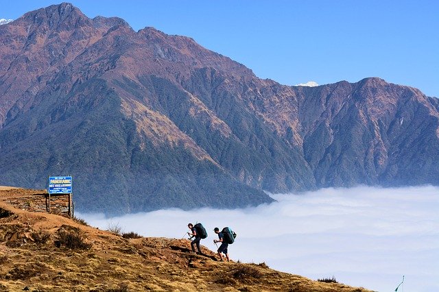
Annapurna Circuit
| Resort: | Annapurna Circuit |
| Operator: | Explore |
| Destination: | Asia, Nepal |
| Price From: | £1750.00 |
Over ViewOne of Nepal’s classic treks, this route makes a full circuit of the Annapurna range over sixteen days. Trek through rhododendron forests, mountain foothills, across barren, rocky landscapes and snow-covered passes, staying in cosy family-run tea house lodges along the way. Thorong La – Cross this challenging high pass, 5416m, offering stunning views across the Himalaya ItineraryDay 1 Trip starts in the Nepali capital KathmanduThe trip starts today in Kathmandu, the busy, colourful and chaotic capital city of Nepal. Your Leader plans to meet everyone in the hotel reception for a welcome meeting at 5 pm. For those that wish, there is the chance to go out together as a group for dinner afterwards. There are no other activities planned for today. Should you miss the welcome meeting, your leader will leave any essential information and details of the best time to catch up with them, at the hotel reception. If you would like to receive a complimentary airport transfer today, you’ll need to arrive into Kathmandu Tribhuvan International Airport (KTM). You should allow at least 45 minutes to reach our hotel in central Kathmandu as traffic congestion in city can be bad. Depending on the arrival time of your flight, should you wish to explore, our hotel is located a short walk from the lively Thamel area. Home to a multitude of outdoor gear, souvenir shops, great bookshops and a huge variety of restaurants, it’s a fun place to wander. Day 2 Trek briefing followed by a walking tour of Old KathmanduAfter breakfast we will have a full briefing on the trekking days ahead, followed by a chance to visit a local hire shop to pick up any last minute equipment still needed. Following this, we then have a walking tour of the city, visiting the bazaars and the temples of old Kathmandu in the company of a local Nepalese guide. Nepal’s bustling capital is a captivating mix of spice sellers and potters, rickshaws and sacred cows, all crowded together amidst a city of vibrant noise and colour. Our sightseeing takes in the sumptuous majesty of Durbar Square and its collection of ornate palaces, courtyards and temples, as well as the Asan Bazaar and the Kumari Ghar, home to the living goddess of the Kumari Devi. Day 3 Drive to Besi Sahar where the Circuit trek commences; hike to Bhulbule (840m)Departing the city this morning we drive west, towards the beautiful mountain landscapes of Central Nepal, home to the towering peaks of the Annapurnas, Dhaulagiri and the iconic Machhapuchhre (the famous ‘Fish Tail’ mountain). Stopping for lunch along the way, on arrival in the foothills around Besi Sahar (760m) we begin our trek up to the Gurung village of Khudi (790m). Following the gorge we pass a sprinkling of small hamlets and tropical forest, before making our way across the Khudi Khola to follow the trail north along the Marsyangdi Valley to Bhulbule (840m). Today’s four and a half kilometre walk is expected to take around three hours with a total ascent of 80 metres. Day 4 Trek from Bhulbule to the ancient village of Jagat (1300m)This morning we cross the Ngadi River by way of a high suspension bridge and continue along its east bank up to the settlement of Bahundanda. The route takes us through the villages of Ngadi and Lampata and to the north-east we are treated to some stunning views of Manaslu (8156m). From Bahundanda we then descend to a stream, before climbing to the village of Lili Bir, from where we continue to follow the trail high above the river. The track then descends to another bridge, at Syange (1190m), where we cross over to the western side of the Marsyangdi and hike up a steep trail to the ancient village of Jagat (1300m). Today’s 14 kilometre walk is expected to take around seven hours with a total ascent of 750 metres and a descent of 350 metres. Day 5 Trek from Jagat to Dharapani (1860m) crossing the Marsyangdi River several timesFrom Jagat the trail descends along a meandering track that follows the Marsyangdi, mirroring the river’s course before winding up through forest to the small village of Chamje (1430m). Crossing the river to the east bank again, we then continue up to the large settlement of Tal (1675m), where we find a number of lodges and shops sharing the landscapes with some breathtaking views of the surrounding valleys. This presents us with an ideal spot to stop for lunch, before we resume our journey onto the village of Karte. The afternoon sees us crossing the river back and forth, snaking our way up the valley and passing through a collection of small villages en route to our final destination at Dharapani. Today’s 15 kilometre walk is expected to take around seven hours with a total ascent of 875 metres and a descent of 180 metres. Day 6 Hike from Dharapani to Chame (2670m) with views of Annapurna II and IVA rocky trail takes us west, following the Marsyangdi up the Manang Valley, where we enjoy some stunning views out towards Annapurna II (7937m) and Annapurna IV. These remote highlands are home to the Manangi people, itinerant traders who have traded salt and yaks across these mountains for centuries. Following in the footsteps of these mountain merchants of old, we head up through forests of oak and maple to Dhanakyu (2290m) and then on to the village of Latemarang (2360m). Our route then winds it way across several forested ridges to Kotho (2590m), from where we have a short easy walk down to Chame (2670m), the region’s administrative headquarters, where the distant views of Lamjung, Annapurna II and Annapurna IV provide a stunning backdrop to our day’s end. Today’s 17 kilometre walk is expected to take around seven hours with a total ascent of 1065 metres and a descent of 390 metres. Day 7 Ascend from Chame to Pisang (3190m) through dense forestsDeparting Chame, we cross over to the northern side of the river and follow a relatively easy trail up through apple orchards to the village of Bhratang (2840m), an old Khampa settlement that is largely abandoned these days. From here we then start along a trail that provides us with some of the most dramatic scenery of the journey so far. Blasted through the surrounding rock, the trail leads through a steep, narrow valley, blanketed in dense forest. As we exit the forest and cross the river over a bridge suspended some 3040m above sea level, we are treated to our first view of the spectacular Paungda Danda, a 1500 metre wall of rock that rises up from the river below. After crossing a ridge that lies festooned with prayer flags and stone cairns, we then reach the large village of Pisang. The village is split into lower and upper Pisang and from the gompa at the top of the town there are some lovely views out across the meandering streets and rambling houses of the lower town. Today’s 14 kilometre walk is expected to take around six hours with a total ascent of 640 metres and a descent of 10 metres. Day 8 Trek from Pisang to Manang (3540m) via Braga with its ancient gompaContinuing along the south side of the river today we make a long climb up and over a ridge that takes us past 3400 metres. From here we enjoy some truly spectacular views of the surrounding peaks, before we descend into the valley and on to Hongde (3325m), a village that has the distinction of an airstrip, a police post and a truly impressive mani wall. Continuing on to Mungli, we then cross back to the north bank of the river and continue to the Tibetan-style village of Bryaga (3475m), where we find an engaging collection of interestingly stacked houses and the largest gompa in the district. The houses lie one on top of the other, the terraces of the upper houses forming the roofs of the ones below, whilst the monastery contains a wonderful collection of Tibetan Thankas that date back some 500 years. From here it is just a short walk on to the large community at Manang, our final destination for the day, where we find a settlement of some 500 houses, a chorten and a long mani wall etched with the Buddhist chant of ‘Om Mani Padme Hum’. Today’s 14 kilometre walk is expected to take around six hours with a total ascent of 380 metres and a descent of 140 metres. Day 9 Acclimatisation day in and around ManangToday has been left free to get a little more used to the conditions at these higher altitudes before we make the crossing of the Thorong La. You can spend the day exploring the area around the village, taking some shorter hikes into the mountains to enjoy the views of the Chulu ranges and Thorong La in the distance. It is important to get some rest today too though, so remember to conserve some energy for the days still to come. An optional four kilometre walk is expected to take around one and a half hours with a total ascent of 200 metres and a descent of 200 metres. Day 10 Steady ascent from Manang to Yak Kharka (4018m)Taking it steady today we trek to Tengi (3620m) and begin a slow climb towards Gunsang (3930m), enjoying the alpine landscapes and abundance of scrub juniper and alpine grasses that grow on these high slopes. The ever expansive views present us with a magnificent panorama that takes in the peaks of Gangapurna (7454m) and Annapurna III (7555m), as we make our way on to our overnight stop in Yak Kharka. Today’s 10 kilometre walk is expected to take around four hours with a total ascent of 510 metres and a descent of 15 metres. Day 11 Hike from Yak Kharka to Thorong Phedi (4450m), last stop before the Thorung La high passOur first port of call today is the small settlement of Letdar (4250m), which we reach after an hour’s steady climb out of Yak Kharka. From here we continue to climb along the eastern bank of the Jarsang Khola, making our way up to Thorong Phedi (4450m). Translating as ‘foot of the hill’, this is the starting point for tomorrow’s long trek up to Thorong La Pass. Today’s seven kilometre walk is expected to take around four hours with a total ascent of 470 metres and a descent of 70 metres. Day 12 Cross the Thorong La (5416m); descend to Muktinath (3800m) with great Dhaulagiri viewsWe make an early start this morning and begin the long climb to the Thorong La, an ascent that should take us some 4 hours (depending upon the fitness of the group and weather conditions). The trail up to the pass follows a route that has been used by local herders for centuries, crossing through moraine and snow and snaking its way steeply up over the rocky ridges. As we approach the pass we are greeted by the sight of a traditional chorten and fluttering prayer flags and as we crest the summit the views before us are simply staggering. A panorama of Himalayan giants lies before us, with the immense Kali Gandaki Valley lying off to the west and the towering peak of Yakgawa Kang (6481m) to the north. After stopping to rest and enjoy the stunning vistas, we then begin the long trek down to Muktinath, a 1600 metre descent that affords us some glorious views of Dhaulagiri (8167m) and Tukuche Peak (6920m). The moraine trail eventually gives way to grassy slopes, with the final part of our journey taking us along the upper reaches of the Jhong Valley to Muktinath and Ranipauwa, where we end our crossing of the Thorong La. Today’s 15 kilometre walk is expected to take around eight to 10 hours with a total ascent of 976 metres and a descent of 1666 metres. Day 13 Visit the famous pilgrimage site at Muktinath; trek to Kagbeni (2800m)This morning we visit two small temples, one an important pilgrimage site for Hindus, the other for Buddhists. After visiting the temples we begin our trek to Kagbeni, via the village of Jong, which avoids the newly constructed road. We spend the night in Kagbeni, the gateway to the region of Mustang. Today’s eight kilometre walk is expected to take around four hours with a total descent of 960 metres. Day 14 Jeep drive from Kagbeni to Tatopani (1190m)With the road now reaching as far as Kagbeni, we’ll cut out what has become a less pleasant section of the Circuit and drive by local jeeps (total journey time around 6 hours) to pick up the trail at Tatopani. The route will pass through Jomsom, the regions’ main hub with an airport and the Thakali village of Marpha, famous for its apples and brandy. We’ll make a stop at Chairo, home to refugees from Tibet before continuing our descent to arrive in Tatopani at 1190 metres. The name Tatopani means hot water and this village is lucky enough to have two hot springs. We can take a well-earned dip in the springs before the final stages of our trek. Day 15 Hike from Tatopani to Shikha (1935m)Today’s trekking is mainly uphill as we reach Durbin Danda then cross the suspension bridge over the Thak Khola then climb steeply up through the forest to the Durbin Danda Pass. The trail then becomes a more gradual climb uphill to the village of Ghara and then on up to Shikha with good views of Kaligandaki Valley and Dhaulagiri Peak (8167m). Today’s nine kilometre walk is expected to take around six hours with a total ascent of 765 metres and a descent of 20 metres. Today’s walk is expected to take around four to five hours. Day 16 Trek through rhododenron forest to Ghorepani (2860m)Today’s trek sets off gradually uphill to Chitre, continuing to the entrance gate of Ghorepani. Along the way you will be captivated by beautiful views of the farm houses scattered across the other side of the valley. From here the trail makes a steep ascent through the rhododendron and magnolia forests to Ghorepani. Today’s eight kilometre walk is expected to take around four hours with a total ascent of 950 metres and a descent of 15 metres. Day 17 Ascend Poon Hill for Annapurna views at sunrise; trek to Ramghai/Hille (1430m)After an early rise this morning we leave our teahouse and make the ascent of Poon Hill in time to catch the sunrise. From the top we should be able to enjoy panoramic views of the whole of the Annapurna Range and, if the weather permits, watch the sun rise over the peaks of Annapurna I, Annapurna South, Machhapuchhare and Dhaulagiri amongst others. The Poon Hill hike is a two-hour return trip and we return to the teahouse in Ghorepani for a well-earned breakfast. Our trek then continues to Banthanti before descending a long stone staircase to Ulleri from where we hike to Ramghai/Hile. Today’s 18 kilometre walk is expected to take around seven hours with a total ascent of 370 metres and a descent of 1760 metres. Day 18 Final morning trek along Burumdi River to Nayapul; drive to Pokhara for post trek relaxationWe have a short walk this morning to the small village of Nayapul where we say goodbye to our trekking crew and drive to Pokhara. Pokhara is Nepal’s second largest town and is far more relaxed than Kathmandu. Its beautiful lakeside setting beneath the imposing shadow of the stunning Annapurna Range, make it the perfect ending point for our trek. There should be time to enjoy some of the town’s many attractions today, with options to visit the thriving Tibetan village of Tashiling, or perhaps take a boat trip out onto the lake to visit the small temple of Barahi Mandir. Today’s four kilometre walk is expected to take around two hours with a total ascent of 90 metres and a descent of 525 metres. Day 19 Drive to KathmanduLeaving Pokhara this morning we drive back to the capital Kathmandu. The drive takes us along the scenic Prithvi Highway and will take approximately six hours. Day 20 Trip ends in KathmanduThe trip ends after breakfast at our hotel in Kathmandu. |


